Showing posts with label 1926 Prairie Census of Canada. Show all posts

Thursday, January 9, 2025

Census of the Prairie Provinces, 1926 now on Ancestry...sort of

Up until now, we could only search for folks who lived in Manitoba, Saskatchewan, and Alberta in the Census of the Prairie Provinces that started on June 1st, 1926 on FamilySearch in their "Canada, Prairie Provinces Census, 1926" collection via the "Canada, Prairie Provinces, Census, 1926" collection specific search page or using the Library and Archives Canada's "Census search" system. FamilySearch and Library and Archives Canada (LAC) both provide access to this census for free. The FamilySearch site even has a pretty good search system that also searches for variations of names, something that the LAC search can't do for us.

So why would we care that Ancestry now includes this census, labelled as "1926 Prairie Census of Canada", as part of their catalogue?

Many folks have their online tree, whether it be public or private, on Ancestry and many like to have one central place to search for information and record details about their ancestors. Of course, Ancestry isn't the only genealogy focused research site but it is probably the one used by the most people. In my case, along with Ancestry, I use almost all the major genealogy related sites in my research (budget permitting!), plus many others sites hosted by organizations such universities, libraries, archives, museums, and private individuals. So I've been using this census for some time now to help me document my Prairie kin.

But back to Ancestry and their "1926 Prairie Census of Canada" collection.

Screen capture of the top part of the "1926 Prairie Census of Canada" search page on Ancestry taken 9 Jan 2025.

On the Ancestry search page for the "1926 Prairie Census of Canada" we can search by the usual personal information such as their first, middle, and last names, along with when and where they were born. We can also search on additional details such gender, marital status, relation to the head of the household, whether they could speak English or French, could they read or write, ethnicity, citizenship, and immigration date. We can also search on the census details such as district and sub-district numbers.

However, you might notice something missing on the right side of the search page. Unlike with the other Canadian censuses that Ancestry has made available on their site, there is no way to browse the images of the pages.

That's because this collection is just an index and the images of the census pages aren't available on Ancestry (at least at this time).

This creates a little bit of a problem since I always stress that we should always look at the images of the source material. 

Why? To see what has been excluded from the index transcription or to confirm that it is the right person we are looking at due to transcription challenges.

So how do we do that with this census?

To start with, you may have searched for the person in this census on Ancestry or it could have popped up as a hint. Here is a screen capture of the page on Ancestry with the details for Donald McMullen, my grandfather.

Screen capture of the Ancestry "1926 Prairie Census of Canada" collection details page for Donald McMullen, age 9 years, in Manitoba, Canada.

As you can see, there is no image on the left side of the index transcription information for us to click on and look at.

We are going to have to do a little bit of work to get to the image since we are going to visit the Library and Archives Canada "Census search" page. Why use the Library and Archives Canada "Census search" since FamilySearch has the same information? FamilySearch doesn't let us search using the enumeration district and sub-district information. The district information is useful for filtering down to just a single page or two when there are multiple people with the same name. Plus with LAC we don't even need an account to view the images.

So we need to write down a few details from that Ancestry details screen:

  • Name
  • Age
  • Residence Place
  • Enumeration District
  • Sub-District

All these details came from the index on the Library and Archives Canada site. By the way, the index for this census on the LAC site originally came from the folks at FamilySearch.

Popping over the Library and Archives Canada "Census search" page I've filled in the key fields with the information from the Ancestry details screen for my grandfather, Donald McMullen:

Screen capture of the Library and Archives Canada Census search page with "1926 (Prairies)" selected, First name of "Donald", Last name of "McMullen", Age 9, in Manitoba with District number 17 and Sub-district number 19 specified in the "Where" "more" section.

Here I've selected to search only the "1926 (Prairies)" census in the "When" section.

In the "Who" section, I've typed in the name exactly how it was found spelled in the Ancestry details along with the age.

When I only selected the "1926 (Prairies)", the "Where" section greyed out all the provinces not covered in this census. This made it easy to only select Manitoba since that is the residence place listed in the details.

The next step is a little more advanced, I need to click on the "More" button under "Place" to display the district and sub-district search boxes. There I filled in the District number, 17 in this case, and Sub-district number of 19.

With all those details, only one result was returned.

Screen capture of the Library and Archives Canada Census search results page of the "1926 (Prairies)" for Donald McMullen, age 9 years, in Manitoba.

A few tips concerning the results page:

  • If you need to change your search don't use your browser's back button. Instead, click on that "Modify search" link at the top to bring up the search screen again. Using the back button will often bring you to a empty search screen and you have to type all the information again.
  • As tempting as it is, don't click on the "digital object(s)" image to view the page. You are going to want to click on the name of the person.

Clicking on the name brings us to the details page. If I had just clicked on the image, I wouldn't be able to see the details about the record on the LAC site that I will want to use in a citation (we all use citations, right?).
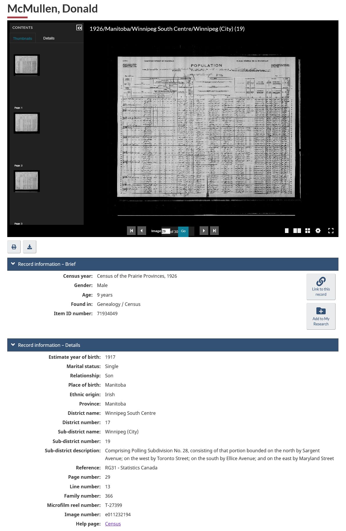
Screen capture of the Library and Archives Canada Census search details page of the "1926 (Prairies)" for Donald McMullen, age 9 years, in Manitoba, item ID number 7193049.

You can now view the image on your screen, print it on your printer, or download it to your computer.

If you choose to download the image to your computer you can either save just the page you at looking at as a JPG or save all the pages in that sub-district as a PDF. 

Census of the Prairie Provinces, 1926, Manitoba, enumeration district 17 Winnipeg South Centre, sub-district 19 Winnipeg (City), page 29; imaged, "Census search", Library and Archives Canada (http://central.bac-lac.gc.ca/.redirect?app=census&id=71934049&lang=eng : accessed 9 Jan 2025); citing ecopy number e011232194.

No matter what you choose to do, you can now review all the details recorded about the person for yourself. One detail that we don't find in the transcription is the address where the person was residing. This could be a street address for a town or city, or the section, township, range, and meridian that we can use to learn more about the property.

Have fun searching this census for your kin who resided in Manitoba, Saskatchewan, or Alberta in 1926!

Friday, January 24, 2020

Converting Section-Township-Range-Meridian to Latitude-Longitude in Canada

In a recent post in the members only British Isles Family History Society of Greater Ottawa Discussion Group on Facebook a question was asked about how to find a group of Saskatchewan homesteads on a map.

If any of your relatives settled in the Canadian Prairie Provinces and you've looked at the 1906, 1911, 1916, 1921, or 1926 census you might have seen the Place of Abode asking about the section, township, range, and meridian for anyone not living in a city or town.

1926 census of Canada, Saskatchewan, district 20, sub-district 23, Rural Municipality of Fairview, p. 2, dwelling 11, family 11, Margaret Gilchrist; RG 31; digital images, Library and Archives Canada, Library and Archives Canada (www.bac-lac.gc.ca : accessed 24 Jan 2020); citing Library and Archives Canada, item no. 1018757.
1926 census of Canada, Saskatchewan, district 20, sub-district 23, Rural Municipality of Fairview, p. 2, dwelling 11, family 11, Margaret Gilchrist; RG 31; digital images, Library and Archives Canada, Library and Archives Canada (www.bac-lac.gc.ca : accessed 24 Jan 2020); citing Library and Archives Canada, item no. 1018757.

The locations were given using the Dominion Land Survey (DLS) method that was used to divide up most of Western Canada (Manitoba, Saskatchewan, Alberta, and parts of British Columbia) into one mile square sections. These coordinates boil down to a legal subdivision, typically one of 4 quadrants - NE/SE/SW/NW, section, township, range, and meridian. I'm not even going to describe how all this came about since the Library and Archives Canada landing page for the Land Grants of Western Canada, 1870-1930, Wikipedia page on the Dominion Land Survey, and the Saskatchewan Land Information Services Corporation page on Measuring Land in Saskatchewan do a much better job than I ever can, so I refer you to those pages.

So, just how do you plot these co-ordinates onto a modern map?

I looked at a number of sites and many of them do a great job if you have only a few locations to plot. However, after between 3 and 20 plots you had to pay for monthly subscription or a small amount, usually less than a dollar and sometimes literally only pennies, to do more. However, I found that the Oil and Gas industry also uses this mapping system since the Dominion Land Survey addresses are used as legal land descriptions. After a bit more searching I came across the SCADALink DLS/LSD to Lat/Long page provided by Bentek System out of Calgary, Alberta, Canada.

Screen capture of Bentek System's DLS/LSD to Lat/Long page with Margaret Gilchrist address.

It isn't the fanciest or prettiest page but, gosh darn, it just works and I love when I come across a web page that is designed for functionality with no bells or whistles.

The census enumerations for Canada generally only asked for the section (SEC), township (TWP), range (RNG), and meridian (MRD). Unless the enumerator wrote down NE, SE, SW, or NW you won't know which quarter of the section they were living on, unless they owned the whole section. In those cases I will just leave the LSD as the number "1" which is in the south-east corner of the section.

In the screen capture above for Margaret Gilchrist from the 1926 census of Canada I entered in the details from the enumeration leaving the LSD as "1". I clicked the Convert button and it did its magic giving a result of 51.345549,-108.257044.

So what can I do with that set of numbers? Well you can click the "Map" button and it will zoom into the coordinates in a Google Map page embedded with the SCADALink page. Or you can copy those numbers into Google Maps directly, maybe even creating your own map plotting where your relatives lived.

Screen capture of Google Maps with Margaret Gilchrist address plotted.
Sometimes you might come across situations where a transcription is missing a key part of the details such as the meridian. This has happened to me several times with the Manitoba, Saskatchewan and Alberta, Canada, Homestead Grant Registers, 1872-1930 collection on Ancestry where the meridian is missing.

Here the record for the transcription for Harold Geo. Armitage's entry is missing "Meridian":
Screen capture of the record page for Harold Geo Armitage in the Manitoba, Saskatchewan and Alberta, Canada, Homestead Grant Registers, 1872-1930 collection on Ancestry.
But since they provide a way to view the image of the register gaes you can check what was really recorded (fourth entry from the top).
"Manitoba, Saskatchewan and Alberta, Canada, Homestead Grant Registers, 1872-1930," database and images, Ancestry (www.ancestry.com : accessed 24 Jan 2020), entry for Harold Geo Armitage, application date 4 Nov 1914, image 6; citing  Homestead Grant Registers. R190-75-1-E. Library and Archives Canada, Ottawa, Ontario, Canada.
"Manitoba, Saskatchewan and Alberta, Canada, Homestead Grant Registers, 1872-1930," database and images, Ancestry (www.ancestry.com : accessed 24 Jan 2020), entry for Harold Geo Armitage, application date 4 Nov 1914, image 7; citing  Homestead Grant Registers. R190-75-1-E. Library and Archives Canada, Ottawa, Ontario, Canada.
As you can see on image 7 it seems that someone forgot to transcribe "2" for the meridian, or more accurately, W2. We can verify that information by searching the Land Grants of Western Canada, 1870-1930 at Library and Archives Canada for an Armitage at section 10, township 49, and range 14. Only one appears in the results.

Screen capture of search for Armitage at section 10, township 49, range 14 in the Land Grants of Western Canada, 1870-1930 at Library and Archives Canada.
Now we can properly map the location!

I hope that this helps you put your ancestors and relatives on the ground in the Prairie Provinces of Canada.