For most folks researching their kin in the land records of Ontario they are dealing with the records in the counties where we have abstract books organized by township, concession, and lot. That isn't the case for those looking for the land records who settled in the more northern districts of Ontario. So please indulge me as we take a journey to those districts of Ontario and look at their land records.
Recently in one of the genealogy groups I frequent on Facebook the following query was posted:
Looking for some help to decipher the information in column 3 on this 1901 census, schedule 2. It is for my ancestor William (Guillaume) Gauthier.
From what I can determine, it says " a NBay b 39 & 40 in 11 con "
I assume NBay is for North Bay and 39 and 40 are lot #’s? Is there any way to locate this location on a map?
The following image was also included:
,%20Sub-district%20Y,%20p%201%20-%20extracted.jpg) |
| Image of the 1901 Census of Canada, Schedule 2, Ontario, District 92 (Nipissing), Sub-district 1, Ferris, p 1 combining the header section of the page with and extract of lines 40 to 50 with line 43 highlighted with a red box; original source of image unknown; image of the full page found on Library and Archives Canada (http://data2.collectionscanada.ca/1901/z/z002/jpg/z000085084.jpg : accessed 3 Feb 2024). |
The first thing to note is that the enumerator has combined the instructions on how to record the information in column 3. In the "Instructions to Chief Officers, Commissioners, and Enumerators" for the Fourth Census of Canada 1901 we find that the "Place of habitation" should really just be prefixed with a single letter to indicate the sort of description:
- a. Name of Municipality
- b. Range or concession and lot, or cadastral number
- c. Street and house number
- d. Or other description
Here, the enumerator has written both "a" and "b".
So the entry in that column "a NBay b 39 & 40 in 11 con" can be translated as "The name of the Municipality, Township, or Parish is North Bay; lots 39 and 40 in the 11th Concession". But is that "North Bay" a reference to a municipality, township, or parish?
The top of the census actually gives us a few important clues to help us answer that question. There we find that it is Schedule No. 2 for the Province of Ontario, District No. 92 Nipissing, Sub-district Y, Polling sub-division No. 1 in Ferris.
| 1901 census of Canada, Schedule 1, Ontario, district 92, sub-district y-1, p. 5, top of page; RG 31; digital images, Library and Archives Canada, Library and Archives Canada (http://data2.collectionscanada.ca/1901/z/z002/jpg/z000084890.jpg : accessed 3 Feb 2024); citing microfilm T-6483. |
Looking at the top of page 5 for Schedule 1 of that same place we see that it is for the Township of Ferris. Why page 5? That is the page referenced in column 1 of Schedule 2. For the 1871 and 1901 Census of Canada, most of the non-population schedule pages don't have a name recorded but instead the page and line number of where the head of household is found on Schedule 1.
With all that information we can surmise that we are looking for lots 39 and 40 in the 11th concession of Ferris Township.
Using the Make A Topographic Map site from the Ministry of Natural Resources and Forestry we can "Search by Location" and then "Select a Township & Lot/Concession" to plot that location on a map. I cover how to do this in my "Finding on the Ground: An Ontario Concession/Lot on a Map" post. The look and feel of site has changed a little bit (what website doesn't change over time) since I wrote that post in 2021 but the steps are basically the same.
So question two has been answered: "Is there any way to locate this location on a map?"
Yet why stop there?
What about locating the land record transactions?
In my talks and blog posts I usually focus on the counties on Ontario. It's about time I also talk about the challenges with the districts of Ontario. Just so that we are clear, these aren't the early districts of Upper Canada like Johnston, Midland, Home, etc. but places like Nipissing, Muskoka, and Parry Sound.
For many of the lots in these district, in the Ontario land record books you won't find them referenced in the Township/Concession/Lot format. Instead they are listed under parcel numbers. So how does one take a known township, concession, and lot number and convert it to a parcel number?
For that we need to visit the Ontario Land Property Records Portal, AKA OnLand, and hope that the historical books they have digitized on that site will point the way.
For this case we will be looking in the Historical Books for the Nipissing Land Registry Office (LRO 36). For the more southern counties we could just search the Abstract/Parcel Register Books for the concession and/or lot and get a list of books to browse through.
 |
| Screen capture taken 3 Feb 2024 of the OnLand LRO 36 Historical Books search results of the Abstract/Parcel Register Books for Concession 11. |
That is not the case here as you can see from the screen capture above.
Instead I will turn to browsing the First Registration Books in the Historical Books for the LRO. These First Registration Books "contain a list of first registrations from registry to land titles (e.g. Crown Patent or Crown plan)." I have found these books useful in translating the concession and lot into a parcel number.
 |
| Screen capture taken 3 Feb 2024 of the OnLand LRO 36 Historical Books listing for the First Registration Books. |
Since we are looking for Ferris Township I selected Book 2 "TOWNSHIPS; D TO L" since Ferris Township should fall within that range of letters. On the first page of that book it does list "Ferris (East)" and "Ferris (West)" so there is hope.
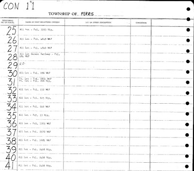
On image 57 of 236 in that book I found the start of the Township of Ferris (East) for lots 1 to 29. So I just kept moving forward through the images until I came to image 80 of 236 and found the page titled "CON 11" in the corner for the Township of Ferris that had the listing for lots 39 and 40.
 |
| Screen capture taken 3 Feb 2024 from OnLand from Nipissing LRO(36), Historical Books, First Registration Book, Book 2, Township of Ferris, Concession 11, Lots 25-41, image 80 of 236. |
There for Lots 39 and 40 we see written: "All Lot - Pcl. 2408 Nip." We also see that lot 41 references the same entry. That "Pcl" abbreviation stands for "Parcel" and it seems to reference "Nipissing". This differs from other entries on the same page that state "W&F". That little detail will be important in the next step.
But now that we have a parcel number we can search the Abstract/Parcel Register Book for the Nipissing Land Registry Office
 |
| Screen capture taken 3 Feb 2024 of the OnLand LRO 36 Historical Books search results of the Abstract/Parcel Register Books for Parcel 2408. |
We find several results returned. One with the Township / Municipality labeled "WIDDIFIELD; FERRIS". That probably would be book we'd want to look in if the reference was "W&F". But we are wanting the "Nip." books so we have a choice, either the NIPISSING "PARCEL 02326 TO 02449" or "LEASEHOLD PARCEL 02401 TO 02600". We don't know from the information available as to whether William Gauthier owned or leased the land but I usually go for the non-leasehold books first.
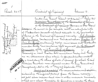
Fairly quickly I found the start of Parcel 2408 on image 152 of 326 from the NIPISSING "PARCEL 02326 TO 02449" book. There I could read that William Gauthier received a Free Grant Patent number 1393 dated 11 Feb 1905. Remember that to get the patent William would have had to have performed settlement duties so he would have been on the land for several years prior. In the first paragraph I could see the description of the land was for Lot Number Thirty-Nine, Broken Lot Number Forty, and Broken Lot Number 41 all in the 11th Concession of the Township of Ferris.
Unlike the Abstract Register Books where we need to consult the instruments to see the details, these Parcel Books have the details in them. For Parcel 2408 there are six pages of information describing how the land was transferred from one person to next...all available for download in a PDF for free.
I will admit that this was a relatively easy example for me to work through. I did make some assumptions that bit me when I was doing my first attempt at locating the property. One assumption was that I should have been looking in the "WIDDIFIELD; FERRIS" book. That was because I forgot to look at the whole page listing the lots for that concession to see what was written elsewhere. That rabbit whole took me about 30 to 45 minutes to get out of.
Just a heads up, some districts and townships may be a bit more of a challenge to research. In one of my presentations I make use of an area in Parry Sound district as an example of researching land in the districts. There I found that some lots were in the Abstract Register books while adjacent lots were recorded in the Parcel Books.
So just be flexible when it comes to researching land records of properties found in the districts of Ontario.

No comments:
Post a Comment