Showing posts with label OnLand. Show all posts

Wednesday, February 7, 2024

Finding on the Ground: Northern Ontario Districts

For most folks researching their kin in the land records of Ontario they are dealing with the records in the counties where we have abstract books organized by township, concession, and lot. That isn't the case for those looking for the land records who settled in the more northern districts of Ontario. So please indulge me as we take a journey to those districts of Ontario and look at their land records.

Recently in one of the genealogy groups I frequent on Facebook the following query was posted:

Looking for some help to decipher the information in column 3 on this 1901 census, schedule 2.  It is for my ancestor William (Guillaume) Gauthier.
From what I can determine, it says " a NBay  b 39 & 40 in 11 con "
I assume NBay is for North Bay and 39 and 40 are lot #’s?  Is there any way to locate this location on a map?

The following image was also included:

Image of the 1901 Census of Canada, Schedule 2, Ontario, District 92 (Nipissing), Sub-district 1, Ferris, p 1 combining the header section of the page with and extract of lines 40 to 50 with line 43 highlighted with a red box; original source of image unknown; image of the full page found on Library and Archives Canada (http://data2.collectionscanada.ca/1901/z/z002/jpg/z000085084.jpg : accessed 3 Feb 2024).

The first thing to note is that the enumerator has combined the instructions on how to record the information in column 3. In the "Instructions to Chief Officers, Commissioners, and Enumerators" for the Fourth Census of Canada 1901 we find that the "Place of habitation" should really just be prefixed with a single letter to indicate the sort of description:

  • a. Name of Municipality
  • b. Range or concession and lot, or cadastral number
  • c. Street and house number
  • d. Or other description

Here, the enumerator has written both "a" and "b".

So the entry in that column "a NBay b 39 & 40 in 11 con" can be translated as "The name of the Municipality, Township, or Parish is North Bay; lots 39 and 40 in the 11th Concession". But is that "North Bay" a reference to a municipality, township, or parish?

The top of the census actually gives us a few important clues to help us answer that question. There we find that it is Schedule No. 2 for the Province of Ontario, District No. 92 Nipissing, Sub-district Y, Polling sub-division No. 1 in Ferris.

1901 census of Canada, Schedule 1, Ontario, district 92, sub-district y-1, p. 5, top of page; RG 31; digital images, Library and Archives Canada, Library and Archives Canada (http://data2.collectionscanada.ca/1901/z/z002/jpg/z000084890.jpg : accessed 3 Feb 2024); citing microfilm T-6483.

Looking at the top of page 5 for Schedule 1 of that same place we see that it is for the Township of Ferris. Why page 5? That is the page referenced in column 1 of Schedule 2. For the 1871 and 1901 Census of Canada, most of the non-population schedule pages don't have a name recorded but instead the page and line number of where the head of household is found on Schedule 1.

With all that information we can surmise that we are looking for lots 39 and 40 in the 11th concession of Ferris Township.

Using the Make A Topographic Map site from the Ministry of Natural Resources and Forestry we can "Search by Location" and then "Select a Township & Lot/Concession" to plot that location on a map. I cover how to do this in my "Finding on the Ground: An Ontario Concession/Lot on a Map" post. The look and feel of site has changed a little bit (what website doesn't change over time) since I wrote that post in 2021 but the steps are basically the same.

So question two has been answered: "Is there any way to locate this location on a map?"

Yet why stop there? 

What about locating the land record transactions?

In my talks and blog posts I usually focus on the counties on Ontario. It's about time I also talk about the challenges with the districts of Ontario. Just so that we are clear, these aren't the early districts of Upper Canada like Johnston, Midland, Home, etc. but places like Nipissing, Muskoka, and Parry Sound.

For many of the lots in these district, in the Ontario land record books you won't find them referenced in the Township/Concession/Lot format. Instead they are listed under parcel numbers. So how does one take a known township, concession, and lot number and convert it to a parcel number?

For that we need to visit the Ontario Land Property Records Portal, AKA OnLand, and hope that the historical books they have digitized on that site will point the way.

For this case we will be looking in the Historical Books for the Nipissing Land Registry Office (LRO 36). For the more southern counties we could just search the Abstract/Parcel Register Books for the concession and/or lot and get a list of books to browse through.

Screen capture taken 3 Feb 2024 of the OnLand LRO 36 Historical Books search results of the Abstract/Parcel Register Books for Concession 11.

That is not the case here as you can see from the screen capture above.

Instead I will turn to browsing the First Registration Books in the Historical Books for the LRO. These First Registration Books "contain a list of first registrations from registry to land titles (e.g. Crown Patent or Crown plan)." I have found these books useful in translating the concession and lot into a parcel number.

Screen capture taken 3 Feb 2024 of the OnLand LRO 36 Historical Books listing for the First Registration Books.

Since we are looking for Ferris Township I selected Book 2 "TOWNSHIPS; D TO L" since Ferris Township should fall within that range of letters. On the first page of that book it does list "Ferris (East)" and "Ferris (West)" so there is hope.

On image 57 of 236 in that book I found the start of the Township of Ferris (East) for lots 1 to 29. So I just kept moving forward through the images until I came to image 80 of 236 and found the page titled "CON 11" in the corner for the Township of Ferris that had the listing for lots 39 and 40.
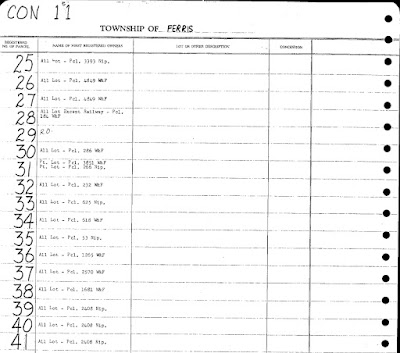
Screen capture taken 3 Feb 2024 from OnLand from Nipissing LRO(36), Historical Books, First Registration Book, Book 2, Township of Ferris, Concession 11, Lots 25-41, image 80 of 236.

There for Lots 39 and 40 we see written: "All Lot - Pcl. 2408 Nip." We also see that lot 41 references the same entry. That "Pcl" abbreviation stands for "Parcel" and it seems to reference "Nipissing". This differs from other entries on the same page that state "W&F". That little detail will be important in the next step.

But now that we have a parcel number we can search the Abstract/Parcel Register Book for the Nipissing Land Registry Office

Screen capture taken 3 Feb 2024 of the OnLand LRO 36 Historical Books search results of the Abstract/Parcel Register Books for Parcel 2408.

We find several results returned. One with the Township / Municipality labeled "WIDDIFIELD; FERRIS". That probably would be book we'd want to look in if the reference was "W&F". But we are wanting the "Nip." books so we have a choice, either the NIPISSING "PARCEL 02326 TO 02449" or "LEASEHOLD PARCEL 02401 TO 02600". We don't know from the information available as to whether William Gauthier owned or leased the land but I usually go for the non-leasehold books first.

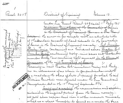
Screen capture taken 3 Feb 2024 of the OnLand LRO 36 Historical Books of the Abstract/Parcel Register Book for NIPISSING Municipality Parcels 02326 to 02449 for Parcel 2408 found starting on image 152 of 326.

Fairly quickly I found the start of Parcel 2408 on image 152 of 326 from the NIPISSING "PARCEL 02326 TO 02449" book. There I could read that William Gauthier received a Free Grant Patent number 1393 dated 11 Feb 1905. Remember that to get the patent William would have had to have performed settlement duties so he would have been on the land for several years prior. In the first paragraph I could see the description of the land was for Lot Number Thirty-Nine, Broken Lot Number Forty, and Broken Lot Number 41 all in the 11th Concession of the Township of Ferris.

Unlike the Abstract Register Books where we need to consult the instruments to see the details, these Parcel Books have the details in them. For Parcel 2408 there are six pages of information describing how the land was transferred from one person to next...all available for download in a PDF for free.

I will admit that this was a relatively easy example for me to work through. I did make some assumptions that bit me when I was doing my first attempt at locating the property. One assumption was that I should have been looking in the "WIDDIFIELD; FERRIS" book. That was because I forgot to look at the whole page listing the lots for that concession to see what was written elsewhere. That rabbit whole took me about 30 to 45 minutes to get out of.

Just a heads up, some districts and townships may be a bit more of a challenge to research. In one of my presentations I make use of an area in Parry Sound district as an example of researching land in the districts. There I found that some lots were in the Abstract Register books while adjacent lots were recorded in the Parcel Books. 

So just be flexible when it comes to researching land records of properties found in the districts of Ontario.
Monday, September 26, 2022

Finding on the Ground: An Urban Address

In my various "Finding on the Ground" series of posts the one type of property I kept glossing over were the lots in the urban areas. I kept ignoring those places for only one reason...it can be a challenge locating the records on the Ontario Land Property Records Portal, AKA OnLand. However, in this post I will walk you through the process and resources I used to find a lot in Galt, now part of Cambridge, Ontario.

The initial question was posted in the Ontario Ancestors group on Facebook:

"I know of a house in Cambridge (Galt) that I would like the Concession and Lot number.
Once I have that I know how to retrieve information off of Onland.ca, I just need the actual Concession/lot.  How do I find this please."
After a bit of back and forth to get the specific address and the person of interest (just a reminder of the importance of providing detailed information in your questions: Asking Good Questions; Creating Good Answers) I learned the following details:

  • The modern address in Galt is: 46 Park Hill Rd (West of the Grand River) in Cambridge, Ontario.
  • She is looking for information about the land transactions involving William John Millican since he own that property around 1883.

And so the adventure began!

Step 1 - Where is it now?

The first step I took was to search the OnLand Property Address in the virtual Waterloo Land Registry Office (58). Why that LRO? I didn't know which office was responsible for Galt or Cambridge so I just typed in Galt, it's shorter than typing Cambridge, in the "Find your Land Registry Office" box and OnLand informed me that it was in "WATERLOO (LRO 58)"

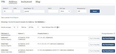
For the address I initially typed "46 Park Hill" but no results were returned. So I just removed the space between "Park" and "Hill". Sometimes you do have to play around with the name of the street to get the "right" name in OnLand. Eight results appeared with almost all of them for 46 Parkhill Road West Cambridge found on Lot 1 in Plan 470 of Cambridge. But there was also a 46 Parkhill Road East. 

Partial screen capture of the Address Search results for 46 Parkhill in Waterlook (LRO 58).
Partial screen capture of the Address Search results for 46 Parkhill in Waterlook (LRO 58) on OnLand.

So which one is it?

I started with an assumption that the 46 ParkHill Road West was the one I wanted so I next switched to the Property Map feature on OnLand and searched by the street name "Parkhill". Three possible streets were listed: PARKHILL CRT, PARKHILL ROAD, and PARKHILL ROAD EAST. Since I didn't see a "PARKHILL ROAD WEST" listed I selected just "PARKHILL ROAD". 

Screen capture of "Search by Street" for Parkhill in Waterloo (LRO 58) on OnLand.

It looks like I choose wisely since that road is west of the Grand River.

I then zoomed out on that map. Just a word to the wise, it does take a few seconds for OnLand to redraw the map so be patient and take it slowly. 

It looked to me that Park Hill Road West might be within Concession 11 possibly on lots 9, 10, or 11 based on the other lot notations nearby. The map also seems to indicate that it is "WGR" (West of Grand River) so it could be within lot 1 or 2 WGR. So we still have some work to do.

Step 2 - Historical Abstract/Index Books

Next it was off to the Historical Books section for the virtual Waterloo Registry Office.

Normally I would browse these books but since I have a plan number from the address search I searched for Plan 470. Amazingly only one result was returned. Unfortunately it seemed like the instruments start from 1905 and I'm looking for property from around 1883. Yet there are still some very useful clues found if I pay attention. On the first page it says "James Patterson's Sy" and the next states "James Patterson Survey" at the top. On the third page it has written near the top "From 10 in 11th Con"

At this point in my research, since I was doing this on a Saturday and it was approaching 6 p.m., I no longer could use OnLand since they shutdown access to these resources at 6 p.m. on Saturday. GRRR!

I decided to go to the "Make a Topographic Map" site from the Ontario Government. Under the Navigation option in the top menu bar I selected Search and then Address as the type of search. There I typed "46 Park hill road west, cambridge" (without the quotes) and the map automagically zoomed in to the location. If I had typed "46 parkhill road west, cambridge" this site was actually smart enough to suggest "46 Park Hill Road West, Cambridge". But I did find that I had to state "road" as part of the address. The "west" was optional since it gave suggestions for the full address.

From there I zoomed in until I spotted faintly written clues like "LOT 3 WEST OF GRAND RIVER CON 11" AND "LOT 2 WEST OF GRANT RIVER CON 11". Looking at what looks to be boundary lines it would seem that "46 Park Hill Rd W" lies within Lot 2 West of Grand River, Concession 11. Again, that is a guess but it seems to match the note from the plan documents.

Next it was off to FamilySearch to look in their copies of the Abstract Index Books found under "Canada, Ontario, Waterloo" for Galt.

Looking on FamilySearch in the Abstract Index Books under "Canada, Ontario, Waterloo" for Galt (v. 1 & 2) I come across in Volume 1 of the Galt books for the "Town of Galt" a page for "Subdivision Lot No. 2 Concession XI West of Grand River: Sometimes called North Halves of Lots Nos. 10 and 11" at https://www.familysearch.org/ark:/61903/3:1:3Q9M-C3H6-T3LM. The details are found on the bottom half of that digitized page. The instruments start in 1841 and go to 1863. Much later on in that same digitized set of books I see "Subdivision Lot No. 2 West of Grand River Conn XI. Sometimes called North halves of Lots Nos. 10 & 11" (https://www.familysearch.org/ark:/61903/3:1:3Q9M-C3H6-TS7M) and those instruments go from 1866 to 1877. That appears to be continuation of the first page but found in Volume 2 of the Galt books. Unfortunately the later volumes for Galt aren't on FamilySearch.

Since I was stuck on FamilySearch I had to wait until OnLand opened up for online business at 9 a.m. on Sunday.

Back on OnLand within the Historical Books for the Waterloo LRO (58) I filtered the township/municipality on "Galt". I noticed that there are books labelled 1, 2, 3, 1A, 2A, etc. There was even a Book 2 which had the description "SUBDIVISION 2". So I wondered if they were the volume numbers seen when looking in the FamilySearch Abstract Index Books for Galt. A quick glance and it seemed like they were. Towards the start of some of the books an index could be found (woohoo!) so I checked the first several pages for each of the books and in Book 3A on image 2 I saw "James Patterson's Survey of Pt. 10 Con XI W.G.R. (470)" and it looks like it started around folio [page] 427. That looked really promising based on what was found recorded for Plan 470. Book 3A only went up to page 220 but the images for Book 3B started at page 221 so I started looking there. Page 427 started at image 414 but I didn't see James Patterson's Survey mentioned there so I went to the next image, 415, and there was "James Patterson's Survey of Part of Lot No. 10 Con XI W.G.R". 

It would seem that each folio is made up of two images, a top and a bottom section. There was Lot No. 1 but the entries were from 1884 to 1889 and I didn't see any Millican's mentioned. But in one of the columns it stated "Cont. on page 431". Next it was off to find page 431 stamped in the upper right corner and it was found on image 422. On the second image from page 431 (image 423) there was "Lot No. 1 James Patterson's Survey (Cont. from 427.).

Extract from OnLand's Waterloo (LRO 58), Abstract/Parcel Register Book, for Galt, Book 3B, image 423 of 446 for Lot No. 1 of James Patterson's Survey continued from p. 427.

What do I see but a B & S, instrument 8227, on 14 Mar 1890 and registered 18 Mar 1890, with the grantor being James Patterson et ux and the grantee listed as W.J. Millican.

Keep in mind that these books for Galt are a real mess when it comes to how the abstracts were recorded since the top of the page stated "Lot No. 11 Concession X" but we have other lots apparently not on that concession listed on the same page.

Step 3 - Ordering

The next challenge might be to get a copy of that B&S instrument, no. 8227. However, a copy isn't available on FamilySearch since they only have the Land Record copy books up to 1875. This means ordering the document from OnLand and I've written how to do that in my post "Finding on the Ground: Ordering from OnLand".

The first step is to "create" a registration number using a prefix code and the instrument number. To find that prefix code I needed to click on the "correct prefix and range" link found on the "Instruments, Plans and Evidence" page accessed from the OnLand Documents page. That link brings us to the ServiceOntario Prefixes and Cross-References page. Opening up Waterloo LRO 58 there is a PDF link for the Instrument Prefix List for Waterloo. Scrolling through the PDF I see that there is a "Galt" entry which covers the time period of 1853 to 1955 and instrument numbers 1 to 55023. That look to be the right place, years, and instrument numbers so the prefix code associated with that instrument number should be "D". Combining the prefix code just identified and the instrument number of 8227 I get a registration number "D8227". This was the only easy part of the whole process!

At this point, if this was my family, I could place the order for $3 plus tax. I might even order some of the other documents mentioning W. J. Millican.

Wrapping it up

I will gladly admit that I really do dislike trying to find the transactions which took place in urban environment. Urban areas can be a really challenge due to issues such as changing boundaries, going from concession and lots to plans or sections, and street names being changed. Of course, how the registrations for Galt are recorded didn't make it any more enjoyable. It turned out that the note from Plan 470 which stated "SURVEY James Patterson" was key to finding William John Millican's property without spending hours looking through all the books. So pay attention to the whole page and surrounding pages for potential clues!

Yet don't give up when looking for the land records of those who had property in urban environments. It is a bit more challenging that those simple concessions and lots but just a rewarding.


Tuesday, August 17, 2021

Finding on the Ground: Ordering from OnLand

You've finally figured out where your ancestors resided in Ontario and have actually found the page in the Abstract/Parcel Register Book within the Ontario Land Property Access Portal, AKA OnLand. You've also checked out the Land Record books on FamilySearch for the county in which they resided but those books end before the date of registration of the instrument you are wanting to find. So what's next?

How about ordering the historical instrument from OnLand?

Such was the case when I wanted to get the instrument for when Louis and Lydia A. Darou sold some of their property which was registered on 25 Oct 1913.

Screen capture from OnLand from Lanark LRO(27), Historical Books, Abstract Parcel Register Book, North Elmsley, Concession 8-10, Concession 10, Lot 27, North East Half, image 395 of 465.

I was able to find the bargain and sale (B & S) for instrument 2H-2701 between John Alexander Stewart and Louis and Lydia A. Darou registered on 19 May 1904 by looking through the "North Elmsley Township (v. H, 2505-2796) 1901-1906" within the "Land records of Lanark County, 1802-1921" collection on FamilySearch.

Alas, FamilySearch doesn't have volume I in their collection for me to look up the next instrument 2I-3241. So it was off to make my first purchase from OnLand.

Before starting an order, you can login with for your free OnLand account. Having an account doesn't let you go back through your orders to re-download any electronically sent items but it does at least keep an order history so you know when you have gone over your genealogy budget. The order tracking also doesn't give you a useful description. In the case of the order I'm going to walk though, all the the order history states for the description is "Instrument". Not exactly helpful.

The first step in the ordering process is to select the correct Land Registry Office (LRO). You should already know it since it is the same LRO from where you found the Abstract/Parcel Register Book for the property. In this case, Lanark (LRO 27). Next, since I am wanting a document, I selected "Documents" from the top menu and then "Instruments, Plans and Evidence" from the next display page since I want to get a copy of an instrument.

That brought me to the page which, although seemingly very simple to deal with, causes the most grief for many ordering an instrument from OnLand for the first time. This is the page asking for the registration number.

Screen capture from OnLand from the Instruments, Plans and Evidence request page.

You see, the registration number isn't just the instrument number you found in the Abstract/Parcel Register Book. No, that would be too easy. Instead you need to find the correct prefix of the type of document your are requesting.

OnLand does provide a link to the starting page with the prefix codes under the text "correct prefix" in the descriptive paragraph. So let's pop over to that page under the OnLand Help Centre / ServiceOntario Prefixes and Cross-References. Here we find a list of the Land Registry Offices. Scroll to the one we want and click on it. In this case, since I'm wanting instruments from the Lanark LRO I clicked on that link and it displayed the list of the possible documents.

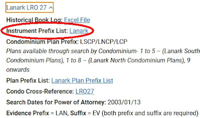
Screen Capture from the OnLand Help Centre ˃ ServiceOntario Prefixes and Cross-References page for Lanark LRO 27 index reference links.

I then selected "Instrument Prefix List: Lanark" (I've circled it above in the image). since I'm looking for the prefix list for the instruments. That action opened up a PDF file with all kinds of codes and dates and even instrument number ranges.

The list can be long and sometimes confusing. Yet we already have the information needed to find the prefix code we are wanting to use:

  • Type of instrument: B & S
  • Date of the instrument: 25 Oct 1913
  • Instrument number: 2I-3241
  • Location: North Elmsley

I wish I could say that there was a standard order for the prefix lists, but there isn't. I took a quasi-random sample from 4 LRO lists and not one was ordered the same way as any of the others. What we need to do is to just look through the list to find something that seem to fit the bill based on the date of the instrument we are hoping to order.

Screen Capture from the Lanark LRO 27 Instrument Prefix List PDF showing North Elmsley prefix codes.

In looking through the list I came across the entries for North Elmsley. Since the date of the instrument I want to get is between Jun 18/1867 and Dec 31/1960 I decided that the prefix code must be "NE". If the registration date of the instrument has been between Jan 25/1856 and Jun 18/1867 then the prefix code would have been NEB. It is really important to pay attention to the dates for when an instrument was registered. If it had been an instrument from the General Register I would have to have looked for those books possibly under the "Miscellaneous" section of the PDF.

I now have the first part of the registration number, "NE". However, the instrument number in the Abstract/Parcel Register Book has this "2I-" before it. We need to toss that part away since it references the volume number and is not needed in this case. Now if we had our hands on the actual Land Record books then we could look up the instrument in the volume "I" books. But we don't so back to OnLand...

In theory, after all that work, the registration number for my request is "NE3241".

Screen capture from OnLand from the Instruments, Plans and Evidence request page with Registration Number NE3241 filled in.

However, when I clicked "Search" I got this scary message:

Screen capture from OnLand from the Instruments, Plans and Evidence request page with warning that Document NE3241 could not be found.

Did I do something wrong? Did I mess up the code?

Actually, no. It is just that the instrument is not yet in their system. I just needed to click on the "Request Document" button. In doing that this message was displayed with a calming green background:

Screen capture from OnLand from the Instruments, Plans and Evidence request page with successful Request Submitted notice.

Time passed...a little more than 72 hours actually. Usually I will give the folks managing OnLand five working days to put the instrument into the system.

To see if they could find and upload the instrument to their computers I had to repeat the process of requesting NE3241 from OnLand. Since I've already done this before and had written down the registration number (remember...WRITE DOWN THE REGISTRATION NUMBER!) this was quick and almost painless.

I guess I did everything right since I when I clicked search this time the following was displayed:

Screen capture from OnLand from the Instruments, Plans and Evidence request page with "1 Instrument found for NE3241" notice.

Now I could purchase the instrument. Generally, for our genealogy research we don't need to have the copy certified and quite often the digital copy is just fine so we can save money and get the copy of the instrument for $3 plus $0.39 HST for a grand total of $3.39.

After going to the checkout and paying for my order I was brought to the page to download the PDF (I've blanked out the email and order number):

Screen capture from OnLand showing a successful order transaction for instrument NE3241.

Make sure you download the copy of the instrument from here just in case the email OnLand sends you with the PDF attached somehow gets lost!


Tuesday, July 20, 2021

Finding on the Ground: Then and Now in Ontario

When dealing with land records in Ontario one of the challenges I still struggle with is locating the property when the family lived in an urban area. So when I saw the following post in the Ontario Genealogy Facebook group I decided to give it another go.

"I have found my 2nd great grandparents, William and Jane Hughes on the 1871, 1881 and 1891 censuses in Orangeville. Is there any way to figure out exactly where in the Orangeville area they lived?"

There were several good suggestions such as looking on the Canadian County Atlas Digital Project and looking at Ontario city directories like those linked to by The Ancestor Hunt. Out of those suggestions, another clue was provided to help me locate the family in the census. William and Jane Hughes had sons Robert and William were tailors. One person suggested looking at the other census schedules since they provide real estate information.

And that is where I am going to start.

Out of the three Canada censuses mentioned in the original query, the 1871 census of Canada is the only one with surviving schedules beyond the Population Schedule. On Ancestry I started looking for a William Hughes residing in Orangeville with a Jane as a possible spouse and Robert and William in the household. Keep in mind that the 1871 census of Canada doesn't list the familial relationships so we have to often make assumptions as to the relationship or use other records to confirm the connect. I also used Ancestry for several reasons:

  • Ancestry has images for the 1871 census available for viewing whereas FamilySearch doesn't. FamilySearch does have the census transcribed but I prefer looking at the image for other clues.
  • The URL for the image which Ancestry presents includes details I can use to view the same image on the Library and Archives Canada site.
  • The search system on the Library and Archives Canada site for censuses is not as powerful as that found on Ancestry

After searching Ancestry I found one household which fit the information about the family.

Here is the family of William Hughes in the Wellington Centre district (34), Orangeville sub-district (i), on page 66, starting at line 1, dwelling 236, family 236.

1871 Census of Canada, Wellington Centre (district 34), Orangeville (sub-district i), Schedule 1, p. 66-67, Household of William Hughes; RG 31; digital images, Library and Archives Canada (http://www.bac-lac.gc.ca/ : accessed 13 Jul 2021); citing microfilm C-9948.

Now I turned to my own prior blog post "Ontario Concession and Lot in the 1871 Census of Canada" to guide me through the process to locate Schedule 4, Return of cultivated land and products on Ancestry. For that I needed to record the following details:

  • District: Wellington Centre (34)
  • Sub-district: Orangeville (i)
  • Page: 66
  • Line: 1

Moving through the virtual filmstrip on Ancestry I quickly came to image 54 of 85 which has the image of the Schedule 4 page which references back to page 66, line 1 of Schedule 1 - Nominal Return of Living (AKA the Population Schedule).

1871 Census of Canada, Wellington Centre (district 34), Orangeville (sub-district i), Schedule 4, p. 12-13; RG 31; digital images, Library and Archives Canada (http://www.bac-lac.gc.ca/ : accessed 13 Jul 2021); citing microfilm C-9948.

If this was a rural property I would have expected to see a concession and lot number after the columns with the 66 and 1. Instead there are dashes which leads me to believe the property is within the village of Orangeville. Even then there are bits of information for us.

  • William owns the property
  • There are 3 acres occupied
  • 3 acres have been improved
  • 1 acre allocated for pasture
  • 1 acre has been used to produce 100 bushels of potatoes

I still don't know where in Orangeville they reside. The directories I did come across were farmer and business directories and I didn't find William Hughes listed with an address. But, based on my own experience, that isn't too surprising. So off to my next stop, the land records.

For this I wanted to look at the Land Record books. Normally I'd start with the Abstract Index books but sometimes the Land Record books include a name index at the front and the Abstract Index books don't. But I don't have a lot, concession, or any other specific about the location. So I took a gamble in the hopes of short-cutting the search.

On FamilySearch I used the catalogue to search for the current county which has Orangeville within its bounds, Dufferin. For the place I typed "Canada, Ontario, Dufferin" to get to the land and property records for that county. Within the Land and property section I selected "Land record of Dufferin County, ca. 1821-1955" to open up the Land Records collection. Scrolling through the list of digitized microfilms I noted that the earlier Orangeville volume "O" books may be indexed. With any luck the index will help me.

I selected DGS 8548530, "Orangeville (indexed) 1825-1863; Orangeville (v. 1) 1841-1869; Orangeville (v. O, indexed) 1864-1869" as a starting place on the hope that William Hughes had land transactions in that time since he was already settled in Orangeville by 1871.

The Town of Orangeville Deeds volume "O" which I was interested in started at image 345 in that digitized microfilm reel.

As an aside, although the current town of Orangeville is in Dufferin County in Ontario and not Wellington County, until 1879 Orangeville was part of Wellington County. Yes, geography can be confusing and boundaries can shift or be created over time. This can actually be seen when you read the description page of that volume where it is recorded:

"This Register contains, exclusive of the Index 175 pages and is to be used in and for the Village of Orangeville in the County of Wellington for the Enregistration of Memorials, under the provisions of the Act of the Legislature of the Province of Canada passed in the Ninth Year of Her Majesty's Reign..."

In the index I came across a mortgage instrument for William Hughes and wife recorded as instrument 133 on folio 299. This looked promising.

After bouncing through the virtual microfilm images I came to instrument 133 starting on image 525. This was an indenture made on the 20th of February, 1868 by William Hughes of the village of Orangeville in the County of Wellington, Province of Ontario and Dominion of Canada, a weaver, and Jane Hughes of the same place as the first two parties with William Armstrong as the other party. 

William and Jane Hughes? That is the couple we are looking for. A good sign.

After reading through a whole bunch of legalese I came across the mention that the property is three acres. Three acres is the same amount of land recorded in Schedule 4 of the 1871 census of Canada for this household. I think I found the property.

A bit further on it states:

"...being composed of Part lot number Eight on the South Side of Factory Street in said Village..."

Just a second!

That's a street name and even a lot number.

This is easy now I though to myself. I just have to put into Google Maps the street name and Orangeville and it will appear.

And no such luck. It looked like there is no Factory Street in present day Orangeville. OK, not a problem. I just have more work to do.

This is where old maps come in handy. A quick search for "old maps of orangeville ontario" (without the quotes) on Google Images brought me to the "2017 - TRAILBLAZERS" page of the Digital Historian Project at the Dufferin County Museum & Archives. On that page I found an early map of Orangeville from 1875 (based on the map filename).

It wasn't too long before I found Factory Street and on the south side of the street there is even a lot 8.

Map of Orangeville, "2017 - TRAILBLAZERS", Digital Historian Project Canada Case Files. (https://digitalhistorianproject.wordpress.com/2017-trailblazers/ : accessed 13 Jul 2021), extract focused on Factory and Centre Streets.

Yet where is that street now? Does it even exist? Has it been renamed?

To answer that question I returned to Google Maps to look at the present day map of Orangeville. Using the clues in the older map. With a little bit of create work in Google Maps I was able to align the map to sort of have the same orientation of the old map. Lo and behold, doesn't this area look like that extract from the old map?

Screen capture from Google Maps centred on Hillside Drive and Centre Street, Orangeville, Ontario, Canada (accessed 13 Jul 2021).

It seems like Factory Street has been renamed as Hillside Drive. I now had a current street name and with that I can possibly use the Ontario Land Property Records Portal, OnLand, Property search function but I still needed a street number. I used the Street View on Google Maps and guessed that it might be around 5 Hillside Drive.

If you haven't used OnLand yet then you are in for a rough ride initially. It has a bit of a learning curve but the results can be worth it. I'm not going to go into the details of how I found the documents though. That will possibly be for a future post.

So when I put that address into the OnLand Property address search it returned:

PT LT 8, PL 170 AS IN MF138033 ; ORANGEVILLE

as the property details.

There is that Lot 8. It is referenced as part of Plan 170 (PL 170).

I wasn't going to celebrate until I could actually see the Abstract/Parcel Index book page for that property and I see William Hughes listed.

When I looked at in the Abstract/Parcel Register Book under Historical Books for the Dufferin Land Registry Office (LRO) and filtered by Orangeville as the municipality the list was way too short so that filter wasn't going to help me. But I did see that the various "PLAN ###" books didn't have a Township/Municipality assigned. Just great...NOT!

Scrolling through the list I quickly (yay!) found PLAN 170 in Book B113. Opening that book I found it only had 63 pages. I can easily deal with looking through 63 pages.

On image 26 I found the start of the Town of Orangeville, Lot 8, Plan 170 pages.

Screen capture from the Dufferin LRO, Historical Books, Abstract/Parcel Index for Town of Orangeville, Lot 8, Plan 170, page 1; Ontario Land Property Records Portal (https://www.onland.ca/ui/ : accessed 13 Jul 2021)

There is the B&S for William Armstrong and wife selling the property to William Hughes on 20 Feb 1868. The instrument is number 132. That is just one instrument before the one describing the mortgage William Hughes took out to pay for the property.

Here is the start of that instrument as found on FamilySearch in the Land Records book for Orangeville, Book "O":

Land records of Dufferin County, ca. 1821-1955, Orangeville (indexed) 1825-1863; Orangeville (v. 1) 1841-1869; Orangeville (v. O, indexed) 1864-1869, instrument 132; Registrar's Office, Orangeville, Ontario; DGS 8,548,530, image 525 (https://www.familysearch.org/ark:/61903/3:1:3Q9M-C3QZ-WF3K : accessed 13 Jul 2021).
Land records of Dufferin County, ca. 1821-1955, Orangeville (indexed) 1825-1863; Orangeville (v. 1) 1841-1869; Orangeville (v. O, indexed) 1864-1869, instrument 132; Registrar's Office, Orangeville, Ontario; DGS 8,548,530, image 525, FamilySearch (https://www.familysearch.org/ark:/61903/3:1:3Q9M-C3QZ-WF3K : accessed 13 Jul 2021).

To answer the original question "Is there any way to figure out exactly where in the Orangeville area they lived?", yes it is possible. All it took was the combined resources of:

  • 1871 Census of Canada, Schedule 1
  • 1871 Census of Canada, Schedule 4
  • Ontario Land Record books on FamilySearch
  • Ontario Land Property Record Portal (OnLand) Historical Abstract/Parcel Index books
  • Google Maps
  • Google Search
  • some effort
  • and a bit of luck


Saturday, March 20, 2021

Finding on the Ground - A Rural Route Address in Ontario

In a recent post in the Ontario Ancestors group on Facebook a person asked:

"Living in the UK I am not familiar with Canadian addresses. The one below I have been told refers to Rural Route 2, it is meant to be farm, but I am not sure it had a name. I found in correspondence from the 1940s and I am keen to find a more exact location if possible, as Google Maps isn't terribly helpful."

I thought I would do a little case study of how to possibly find the location of the property. Be forewarned, there are assumptions being made since this is all the information I had at the time.

The first step I took was to look in the "Canada, Voters Lists, 1935-1980" collection found on Ancestry since that collection does cover more recent, from a genealogy point of view, events. 

Screen capture of the results from searching the "Canada, Voters Lists, 1935-1980" on Ancestry with first name Margaret, last name Cowie, keyword Kemptville.

Knowing that Kemptville is the Leeds and Grenville United Counties the first entry from 1949 looks really promising.

Canada, Canada, Voters Lists, 1935-1980, 1949 Voters List for the Electoral District of Grenville-Dundas. Rural Polling Divition No. 46-1, Township of South Gower: 1 [3140 stamped], Mrs. Margaret Cowie; digital images, Ancestry.com, Ancestry.com (www.ancestry.com : accessed 20 Mar 2021); citing Library and Archives Canada microfilm M-4836.

Looking at the line for Mrs. Margaret Cowie, the address appears to match exactly what was originally posted in the query. Of course, this is an assumption that it is the correct person since we don't have any other details but let's go with this. Just above her is listed "Cowie, Alexander, gentleman, RR2 Kemptville".  Odds are, but not completely certain, Alexander is her husband.

Assuming that is the correct household, where are they?

For that we need to look at the top of that same page:

Canada, Canada, Voters Lists, 1935-1980, 1949 Voters List for the Electoral District of Grenville-Dundas. Rural Polling Divition No. 46-1, Township of South Gower: 1 [3140 stamped], heading; digital images, Ancestry.com, Ancestry.com (www.ancestry.com : accessed 20 Mar 2021); citing Library and Archives Canada microfilm M-4836.

We see that the voters list is from the Township of South Gower and is "Comprising the 1st, 2nd, 3rd and 4th Concessions of South Gower, and not including the the 2nd and 3rd Concessions of South Gower which were formerly part of North Gower". 

With the details we have gathered: name, township, and date, we have enough basic information for the next step, visiting the Ontario Land Registry Access site AKA OnLand

So what can we find in the Abstract/Parcel Register Books within the Historical Books section for the Grenville Land Registry Office (LRO)? After filtering by South Gower in the Township/Municipality box I selected the book for "Concessions 1, 2 , 3". Then it just became an exercise of looking through the pages. 

Screen capture from Onland.ca of the Abstract/Parcel Register Book in the Historical Books section of the Grenville Land Registry office filtered on South Gower.

There are 253 pages but that is easy (compared to some of the other books) since I don't need to read all the pages but only the lines around the 1940s.

On image 33 of that book I came across a transaction for "Deed Under Power of Sale" on 8 Jan 1941 from "The Commissioner of Agricultural Loans" to "Alexander Cowie and Margaret Cowie, Joint Tenants" for the Front half, 100 acres on Concession 1 Lot 6. The names and time period appear to be right. That just might be the property that is being sought.

Grenville (LRO 15), OntarioSouth Gower Concession 1, 2, 3: 33, G-3018, Deed Under Power of Sale to Alexander Cowie and Margaret Cowie, Jt. Tenants, 8 Jan 1941; digital images, Teranet Property & Registration Services, OnLand: Ontario Land Registry Access (https://www.onland.ca/ : accessed 20 Mar 2021).
Grenville (LRO 15), Ontario South Gower Concession 1, 2, 3: 33, G-3018, Deed Under Power of Sale to Alexander Cowie and Margaret Cowie, Jt. Tenants, 8 Jan 1941; digital images, Teranet Property & Registration Services, OnLand: Ontario Land Registry Access (https://www.onland.ca/ : accessed 20 Mar 2021).

So where is Concession 1, Lot 6 in South Gower? For that I went to the digitized map from The Canadian County Atlas Digital Project for South Gower. These maps were created between the 1860s and 1880s. 

Map of South Gower, Grenville County, Ontario from the The Canadian County Atlas Digital Project.

On that map we are fortunate to actually have a name listed on the property. Checking the Map of the United Counties of Leeds and Grenville created under the direction of H. F. Walling in 1861, which just so happens to match the map from The Canadian County Atlas Digital Project, it would seem that the tract of land was occupied by a Mrs. Tripp around 1861. That matches up with the transactions found on the previous page in the Abstract/Parcel Register Book where I found an entry for an Alexander and Margaret Cowie.

What about putting that property on a map that includes current details. For that I popped over to Topographic maps on the Ontario Government site. Once I accepted the "Ontario Parcel License Agreement" disclaimer I then selected from the Navigation bar the option to Search. One of the options is to search by Lot/Concession/Township. So I selected from the various drop down boxes the township of South Gower, Concession 1, Lot 6 and it brought me to the property on the map.

Using the information from that map and a little bit of playing around in Google Maps here is where the property is on a map of today:

Concession 1, Lot 6 in the township of South Gower highlighted in a screen capture from Google Maps.

Is it 100% percent certain this is where the Margaret Cowie in the address we are looking for resided?

 Not a chance

I've had to make several assumptions. However, unless other information is forthcoming it is a good starting point. This short case study also shows how you can use various online resources to possibly locate a person just from a Rural Route address in Ontario.