Tuesday, August 24, 2021

Finding on the Ground: Wrap Up

This wraps up, at least for now, what I've been calling my "Finding on the Ground" series of blog posts.

It all started back in March 2020 with what I thought to be a simple question on finding the agricultural schedule of the 1861 census. Little did I know that I would end up digging through various census schedules, delve into the "Land and property" collections on FamilySearch, initially struggle with OnLand, give a workshop, and also speak to several genealogy societies about the challenges of land research in Ontario...all while in the midst of a pandemic.

I've gathered the links to each blog post I've written on this general subject from the past year or so. I may periodically update this post if (probably when) I have additional posts on this subject.

Censuses

Finding on the Ground

Miscellaneous:

It has been a learning experience for me and hopefully the information provided will help you in your own research journey.

[Updated 7 Feb 2024]

Tuesday, August 17, 2021

Finding on the Ground: Ordering from OnLand

You've finally figured out where your ancestors resided in Ontario and have actually found the page in the Abstract/Parcel Register Book within the Ontario Land Property Access Portal, AKA OnLand. You've also checked out the Land Record books on FamilySearch for the county in which they resided but those books end before the date of registration of the instrument you are wanting to find. So what's next?

How about ordering the historical instrument from OnLand?

Such was the case when I wanted to get the instrument for when Louis and Lydia A. Darou sold some of their property which was registered on 25 Oct 1913.

Screen capture from OnLand from Lanark LRO(27), Historical Books, Abstract Parcel Register Book, North Elmsley, Concession 8-10, Concession 10, Lot 27, North East Half, image 395 of 465.

I was able to find the bargain and sale (B & S) for instrument 2H-2701 between John Alexander Stewart and Louis and Lydia A. Darou registered on 19 May 1904 by looking through the "North Elmsley Township (v. H, 2505-2796) 1901-1906" within the "Land records of Lanark County, 1802-1921" collection on FamilySearch.

Alas, FamilySearch doesn't have volume I in their collection for me to look up the next instrument 2I-3241. So it was off to make my first purchase from OnLand.

Before starting an order, you can login with for your free OnLand account. Having an account doesn't let you go back through your orders to re-download any electronically sent items but it does at least keep an order history so you know when you have gone over your genealogy budget. The order tracking also doesn't give you a useful description. In the case of the order I'm going to walk though, all the the order history states for the description is "Instrument". Not exactly helpful.

The first step in the ordering process is to select the correct Land Registry Office (LRO). You should already know it since it is the same LRO from where you found the Abstract/Parcel Register Book for the property. In this case, Lanark (LRO 27). Next, since I am wanting a document, I selected "Documents" from the top menu and then "Instruments, Plans and Evidence" from the next display page since I want to get a copy of an instrument.

That brought me to the page which, although seemingly very simple to deal with, causes the most grief for many ordering an instrument from OnLand for the first time. This is the page asking for the registration number.

Screen capture from OnLand from the Instruments, Plans and Evidence request page.

You see, the registration number isn't just the instrument number you found in the Abstract/Parcel Register Book. No, that would be too easy. Instead you need to find the correct prefix of the type of document your are requesting.

OnLand does provide a link to the starting page with the prefix codes under the text "correct prefix" in the descriptive paragraph. So let's pop over to that page under the OnLand Help Centre / ServiceOntario Prefixes and Cross-References. Here we find a list of the Land Registry Offices. Scroll to the one we want and click on it. In this case, since I'm wanting instruments from the Lanark LRO I clicked on that link and it displayed the list of the possible documents.

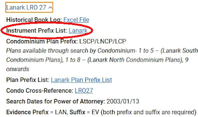
Screen Capture from the OnLand Help Centre ˃ ServiceOntario Prefixes and Cross-References page for Lanark LRO 27 index reference links.

I then selected "Instrument Prefix List: Lanark" (I've circled it above in the image). since I'm looking for the prefix list for the instruments. That action opened up a PDF file with all kinds of codes and dates and even instrument number ranges.

The list can be long and sometimes confusing. Yet we already have the information needed to find the prefix code we are wanting to use:

  • Type of instrument: B & S
  • Date of the instrument: 25 Oct 1913
  • Instrument number: 2I-3241
  • Location: North Elmsley

I wish I could say that there was a standard order for the prefix lists, but there isn't. I took a quasi-random sample from 4 LRO lists and not one was ordered the same way as any of the others. What we need to do is to just look through the list to find something that seem to fit the bill based on the date of the instrument we are hoping to order.

Screen Capture from the Lanark LRO 27 Instrument Prefix List PDF showing North Elmsley prefix codes.

In looking through the list I came across the entries for North Elmsley. Since the date of the instrument I want to get is between Jun 18/1867 and Dec 31/1960 I decided that the prefix code must be "NE". If the registration date of the instrument has been between Jan 25/1856 and Jun 18/1867 then the prefix code would have been NEB. It is really important to pay attention to the dates for when an instrument was registered. If it had been an instrument from the General Register I would have to have looked for those books possibly under the "Miscellaneous" section of the PDF.

I now have the first part of the registration number, "NE". However, the instrument number in the Abstract/Parcel Register Book has this "2I-" before it. We need to toss that part away since it references the volume number and is not needed in this case. Now if we had our hands on the actual Land Record books then we could look up the instrument in the volume "I" books. But we don't so back to OnLand...

In theory, after all that work, the registration number for my request is "NE3241".

Screen capture from OnLand from the Instruments, Plans and Evidence request page with Registration Number NE3241 filled in.

However, when I clicked "Search" I got this scary message:

Screen capture from OnLand from the Instruments, Plans and Evidence request page with warning that Document NE3241 could not be found.

Did I do something wrong? Did I mess up the code?

Actually, no. It is just that the instrument is not yet in their system. I just needed to click on the "Request Document" button. In doing that this message was displayed with a calming green background:

Screen capture from OnLand from the Instruments, Plans and Evidence request page with successful Request Submitted notice.

Time passed...a little more than 72 hours actually. Usually I will give the folks managing OnLand five working days to put the instrument into the system.

To see if they could find and upload the instrument to their computers I had to repeat the process of requesting NE3241 from OnLand. Since I've already done this before and had written down the registration number (remember...WRITE DOWN THE REGISTRATION NUMBER!) this was quick and almost painless.

I guess I did everything right since I when I clicked search this time the following was displayed:

Screen capture from OnLand from the Instruments, Plans and Evidence request page with "1 Instrument found for NE3241" notice.

Now I could purchase the instrument. Generally, for our genealogy research we don't need to have the copy certified and quite often the digital copy is just fine so we can save money and get the copy of the instrument for $3 plus $0.39 HST for a grand total of $3.39.

After going to the checkout and paying for my order I was brought to the page to download the PDF (I've blanked out the email and order number):

Screen capture from OnLand showing a successful order transaction for instrument NE3241.

Make sure you download the copy of the instrument from here just in case the email OnLand sends you with the PDF attached somehow gets lost!


Tuesday, August 10, 2021

1921 Census and Addresses in Ontario

Over the past year I've written about finding the location of a property in Ontario in the 1851, 1861, 1871, 1901, and 1911 Censuses of Canada. I've even written about the "missing" images of the 1861 Census of Canada West on Ancestry. A number of times I've mentioned that the schedules for the 1881 and 1891 Censuses of Canada which have the property details didn't survive to the present day. So this leaves the 1921 Census of Canada to be covered (at least until the 1931 Census of Canada is released to the public). So off we go...

Much like the 1911 Census of Canada, only "Schedule 1, Population" was preserved to be digitized and the other four schedules no longer exist. But like the 1911 Census of Canada, the Population schedule for the 1921 Census of Canada can include specific details of where the household resided.

Before we look at what we might find we need to read what was required to be recorded. The information can be found on the Census of Canada, 1921 landing page at Library and Archives Canada under the Column headings and interpretation section. For column 4, the description says:

Column 4. Place of Abode (Section or Township)
In rural localities, give parish, section, township, range and Meridian.

What do the instructions to the enumerators state? For that we need to read the "Sixth Census of Canada, 1921, Instructions to Commissioners and Enumerators". On page 20 and 21 we find written:

71. Columns 4 and 5. - Place of Abode.  In the case of a city town or incorporated village (see Instructions Nos. 55 and 56) the enumerator will enter the Number of the house and the Street in column 4 and the name of the Ward in column 5. In the case of rural districts, the name of the Township, Lot, Parish or Cadastral number will be entered in column 4 and the name of the Municipality in column 5.

Provided, however, that in Manitoba, Saskatchewan and Alberta, the Section, Township, Range and Meridian will be entered respectively in columns 4, 4a, 4b and 4c, adding the name of the Municipality, Local Improvement District or Unorganized Territorial Unit, where such exists, in column 5.

Let's look at some examples of what might be found in the records for Ontario.

The 1921 census of Canada is available on the Library and Archives Canada (LAC) site for free. You can search for people and view pages there. It is also on Ancestry.ca under their "1921 Census of Canada" collection. It is free at access on Ancestry as long has you have a login account but you DO NOT need a paid subscription!

For non-urban locations you will quite often only see the township recorded such as we find for the district of Bruce South, sub-district of Huron Township, Division 1:

1921 census of Canada, Ontario, district 70, sub-district 36, Huron Township, p. 5; RG 31; digital images, Ancestry.com Operations, Inc., Ancestry.com (www.ancestry.com : accessed 17 Nov 2013).
1921 census of Canada, Ontario, district 70, sub-district 36, Huron Township, p. 5; RG 31; digital images, Ancestry.com Operations, Inc., Ancestry.com (www.ancestry.com : accessed 17 Nov 2013).

Yet some of the enumerators went the extra distance (mile? kilometre?) and also included the concession and lot number for the property as seen in this extract from Middlesex East, London Township:

1921 census of Canada, Ontario, district 102, sub-district 14, London Township, p. 3; RG 31; digital images, Ancestry.com Operations, Inc., Ancestry.com (www.ancestry.com : accessed 12 Aug 2018).
1921 census of Canada, Ontario, district 102, sub-district 14, London Township, p. 3; RG 31; digital images, Ancestry.com Operations, Inc., Ancestry.com (www.ancestry.com : accessed 12 Aug 2018).

As we can see, not only did the enumerator record that the household of John L. Morris is in London Township but they are on Concession 3, lot 18.

What about the folks in the villages, towns, and cities?

Again, it depends on the enumerator and type/size of the city, town, or village. For example, we can see that the household of Charles Heatherington is residing at 94 Hamilton in Dalhousie Ward, Ottawa.

1921 census of Canada, Ontario, district 71, sub-district 46, Ottawa, p. 4; RG 31; digital images, Ancestry.com Operations, Inc., Ancestry.com (www.ancestry.com : accessed 1 Jul Aug 2020).
1921 census of Canada, Ontario, district 71, sub-district 46, Ottawa, p. 4; RG 31; digital images, Ancestry.com Operations, Inc., Ancestry.com (www.ancestry.com : accessed 1 Jul Aug 2020).

Unfortunately, that is not always the case. Here the enumerator for Kingsville only recorded the street name. This is quite common for the smaller towns and villages.

1921 census of Canada, Ontario, district 78, sub-district 34, Kingsville p. 9; RG 31; digital images, Ancestry.com Operations, Inc., Ancestry.com (www.ancestry.com : accessed 8 Sep 2014).
1921 census of Canada, Ontario, district 78, sub-district 34, Kingsville p. 9; RG 31; digital images, Ancestry.com Operations, Inc., Ancestry.com (www.ancestry.com : accessed 8 Sep 2014).

Yet it still helps us narrow down where the people lived. And any clue, no matter how small, is a good clue!


Tuesday, August 3, 2021

Finding on the Ground: An Ontario Concession/Lot on a Map

You have finally figured out where your rural Ontario ancestor lived by finding the location in the census records (1851, 1861, 1871, 1901, or 1911) or through other means and have the township, concession, and lot details. Now you want to take a road trip and actually stand where they may have trod. 

So let's find that location on a map!

At the end of my previous post "Finding on the Ground - A Rural Route Address in Ontario" I skipped over the detailed process of how to do this. Now I'm going to walk you through the steps I took but using a different property than in that example.

The first step is to visit the Ontario "Topographic maps" site and click on the "Make a topographic map now" button. This will redirect you to the "Make a Topographic Map" page hosted by the Ontario Ministry of Natural Resources and Forestry. After a few moments a disclaimer will appear concerning the Ontario Parcel Licence Agreement. Read through it and at the bottom of the box click the "I Accept" button to continue (assuming you do agree to the license).

At the top of the page is a menu bar. Click on the word "Navigation" then the "Search" button (as highlighted below):

Screen capture of the menu bar with Navigation selected and the Search button highlighted from the Ontario "Make a Topographic Map" site.

A menu will appear asking how you want to Perform a Search. Since you have the Township, Concession, and Lot of the property you will want to select "Lot/Concession/Township" from the list:

Screen capture of the "Perform a Search" menu from the Ontario "Make a Topographic Map" site.

You are now prompted for the Township, Concession, and Lot details. Each of the items to be filled in need to be selected from the drop down item list. The Concession and Lot items change based on the Township and Concession selected.

Here is filled in the details for my 4th great-grandfather, Alexander Fraser, who resided in Drummond Township, on the 2nd Concession in lot 12 in the 1851 and 1816 censuses of Canada West.

Screen capture of the "Search by Twp/Lot/Concession" menu from the Ontario "Make a Topographic Map" site with details of Drummond Township, Concession 2, Lot 12 filled in.

Clicking on the Search button will bring you to the property on the map and highlight it in orange like you see below.

Screen capture of the search result returned by "Search by Twp/Lot/Concession" from the Ontario "Make a Topographic Map" site for Drummond Township, Concession 2, Lot 12.

You can zoom in and out of the map to see where the property is in relation to other places. In the bottom corner of the map beside the scale bar there is even a button to show an imagery map instead of the default topographic map.

Great, you have the location on the map. 

But what about getting directions to the place? 

For this I generally just right-click my mouse (I have a Windows computer, not too certain how a Mac or iPad user will do that) on the orange box near a road. This will being up a box with different actions. However, it also gives the latitude and longitude of where you right-clicked.

Screen capture of the search result returned by "Search by Twp/Lot/Concession" from the Ontario "Make a Topographic Map" site for Drummond Township, Concession 2, Lot 12 with the action box displayed.

We now have the location of Lat: 44.937° N and Lon: 76.194° W. You can even copy that text into your clipboard. Why do that? For the next step which is using Google Maps.

Open up Google Maps and in the Search Google Maps box put in the coordinates you got from the map on the Make a Topographic Map site.

Screen capture from Google Maps with the coordinates entered for 44.937° N 76.194° W.

Just a heads up, you have to remove the "Lat:" and "Lon:" words if you do a copy and paste of the coordinates for this to work.

If everything has worked properly then Google will bring you to the location on their map.

Screen capture from Google Maps for the coordinates 44.937° N 76.194° W and Satellite view selected.

With the location pinpointed you can ask Google for driving directions, save the location if you have logged in with your Google account, send to your phone, or even share with others via social media. If the Google Streetview car has driven past the place you can even see what the view looks like if you were standing on the road.

You might even make your own custom Google Map highlighting the various properties of nearby ancestors and other connected relatives.

Enjoy your road trip!